
Unseen Potential of Drones in Livestock Management
go.ncsu.edu/readext?963595
en Español / em Português
El inglés es el idioma de control de esta página. En la medida en que haya algún conflicto entre la traducción al inglés y la traducción, el inglés prevalece.
Al hacer clic en el enlace de traducción se activa un servicio de traducción gratuito para convertir la página al español. Al igual que con cualquier traducción por Internet, la conversión no es sensible al contexto y puede que no traduzca el texto en su significado original. NC State Extension no garantiza la exactitud del texto traducido. Por favor, tenga en cuenta que algunas aplicaciones y/o servicios pueden no funcionar como se espera cuando se traducen.
Português
Inglês é o idioma de controle desta página. Na medida que haja algum conflito entre o texto original em Inglês e a tradução, o Inglês prevalece.
Ao clicar no link de tradução, um serviço gratuito de tradução será ativado para converter a página para o Português. Como em qualquer tradução pela internet, a conversão não é sensivel ao contexto e pode não ocorrer a tradução para o significado orginal. O serviço de Extensão da Carolina do Norte (NC State Extension) não garante a exatidão do texto traduzido. Por favor, observe que algumas funções ou serviços podem não funcionar como esperado após a tradução.
English
English is the controlling language of this page. To the extent there is any conflict between the English text and the translation, English controls.
Clicking on the translation link activates a free translation service to convert the page to Spanish. As with any Internet translation, the conversion is not context-sensitive and may not translate the text to its original meaning. NC State Extension does not guarantee the accuracy of the translated text. Please note that some applications and/or services may not function as expected when translated.
Collapse ▲As a child, the dream of soaring above the world and observing life from above was captivating. Today, this dream is a reality through Unmanned Aerial Vehicles (UAVs), or drones. The incredible technology behind these UAVs has come a long way, and their applications in agriculture, particularly in crop management, are becoming almost common place. However, their potential in cattle production remains largely untapped. I think there are real practical applications for cattlemen to utilize this technology to assist farmers with pasture-based beef production.
The most obvious application of UAVs in cattle production is scouting and counting animals. UAVs can be used to locate cattle. I have found it can be challenging to locate animals when they are loafing in the woods on a hot day. UAVs and trees usually don’t mix, so just time flights when animals are actively grazing to observe them from the air.
Current “prosumer” drones have high-definition video and still cameras. These cameras can capture very high quality images, and most transmit a high definition live-feed back to the controller, phone, or tablet for real time monitoring. Some UAVs are specifically designed for this type of work. They are equipped with Zoom cameras. A drone with a Zoom camera combined with a virtual reality headset is an ideal setup for monitoring the herd from above.
Note, to comply with FAA regulations, the pilot, or a visual observer, needs to be in visual contact at all times during the flight. Monitoring the flight with a virtual reality headset requires a second person to be the visual observer to comply with FAA visual sight regulations.
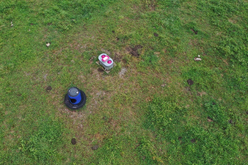
This shows the frost proof drinker is full of water and functioning.
UAVs can also check infrastructure. Aerial robots can swiftly inspect water tanks, identify downed trees, and assess fences. Usually, this can be done with a quick flight using the live feed from the camera transmitted back to the “ground station”. However, drones can be used to create an aerial survey of the farm. This is something that is ideal when recording trenched water lines for the future. The survey can then be used to locate the water lines in the future using the geolocated aerial survey. This technique can also be useful when clearing land. An aerial survey allows for more efficient planning of fences, water tanks, and roads.
Heat detection is critical for efficient artificial breeding management of cattle. I experimented recently with checking heat from the air. I used Estrotect patches. These indicate when animals have been ridden because they are in heat and will stand for other animals. When the patches have been activated, they change color from gray to bright pink, orange, or green. I could see these bright neon activated patches from 400 feet. However, reading ear tags at 400 feet is a little more challenging. Freeze branding animals so the brand can be seen from the ground (as well as from above) would be a practical solution.
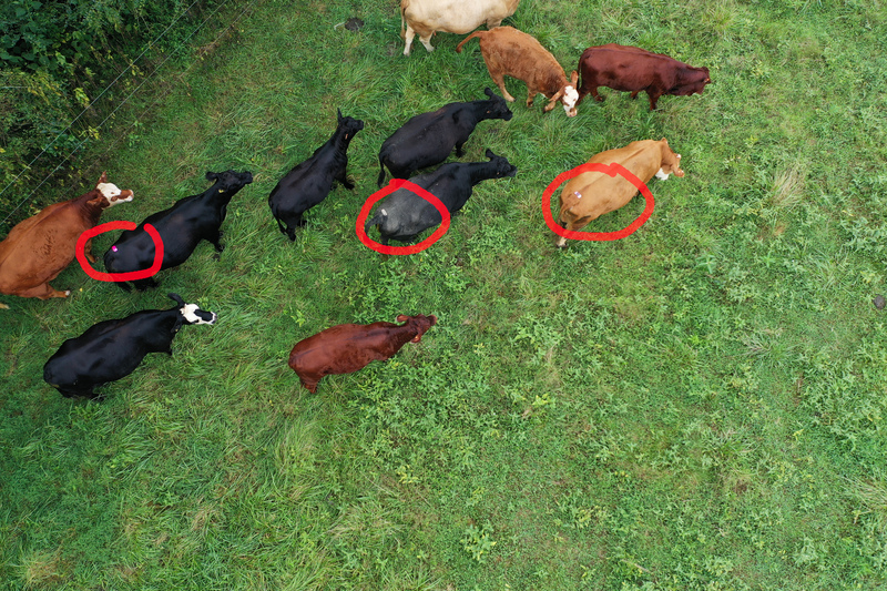
This shows three Estrotect Heat Detection Patches from the air. Two are not active and one is bright pink indicating heat.
Besides taking pictures and observing from above, drones can also be used to herd cattle. I’ve experimented with this on my small herd of animals. The animals move away from the drone once they become aware of it. By positioning the drone 20 feet or so above the cattle, they sense the prop wash and can hear the noise of the propellers. Once they are aware of the drone, they move away and can be herded or driven.
Beefree Agro is an Israel company that is offering a commercial solution for farmers. They have developed software that can transform a drone into a robotic flying cowboy, automatically herding cattle, conducting head counts, and monitoring water tanks.
Other UAV uses for livestock production are monitoring pastures for rotational grazing, and drones could be used to collect data on both quantity and nutritional value of pastures. Quality and quantity data could also be used to optimize hay harvest.
Really, the sky is the limit (no pun intended). I have experimented with locating red imported fire ant mounds from the air. My experience is fire ant mounds can be detected from the air after the pasture has been grazed or mowed. If there is tall grass, the mounds are obscured from aerial observation. It is possible to locate the mounds on an aerial survey and then develop a treatment map or treatment prescription. Knowing where the ants are reduces the time and insecticide needed for control.
To utilize drones on farm, an FAA Unmanned Aerial License is required to be legal. You do not need a license to fly as a hobbyist, but commercial operators need to be licensed. Deciding which UAV to purchase can be daunting, too. What to purchase can change quickly as UAV companies develop new products. If you are interested, do a little research and get started. To keep things simple and focused, decide on a task you want to accomplish. Purchase a UAV for that task, and experiment. I am certain you will quickly find additional uses for an eye in the sky. Using a drone can literally change your perspective of your farming operation.
As always, if you have UAV or any other agricultural questions, please contact the Caldwell Extension Center (828-757-1290).